Articles
| Name | Author | |
|---|---|---|
| Case Study: Greater accuracy brings greater efficiency at Norwegian | Stig Patey, Captain B737 / Manager Fuel Savings, Norwegian | View article |
| Case Study: Air France avoids the avoidable and stays a step ahead with eWAS | Mathieu Durang-Gobert, Flight Operations Support Manager, Air France | View article |
| Digitalize your ramp | Michael Muzik, Product Manager and Consultant, Lufthansa Systems | View article |
Case Study: Air France avoids the avoidable and stays a step ahead with eWAS
Author: Mathieu Durang-Gobert, Flight Operations Support Manager, Air France
Subscribe
Air France avoids the avoidable and stays a step ahead with eWAS
Upgrading to Next Generation Flightdeck Weather Awareness
Weather was once just a fact of life for aircraft, their passengers and crew. However, there is no good reason why it should remain so today. We want to share with readers some thoughts on weather hazards and some information about how Air France is using eWAS (EFB Weather Awareness Solution) to ensure that, even if its pilots can’t control the weather, they can certainly avoid severe weather that would disrupt the flight, potentially damage the aircraft and threaten comfort or even safety.
THE IMPACT OF WEATHER EVENTS
Weather is dynamic with different types of phenomena that should be avoided, such as convection, lightning and clear air turbulence (CAT) which cannot be detected by the onboard radar and, according to IATA, is the leading cause of injury in non-fatal accidents. IATA also says that more than 25 percent of serious injuries result in diversion and therefore recommends that airlines should invest in a turbulence management strategy. Having a weather application during the briefing phase on the ground and in-flight in the cockpit will preserve the most accurate view on any changeable severe weather situation.
Such advice is set against the background that the annual cost to airlines for flight disruptions is around $60 billion. One factor that causes flight disruption is severe weather, which can lead to damage to aircraft and engines, can injure the crew as well as passengers and can disrupt the flight schedule for that flight and for following flights causing a knock-on effect. Also, EU compensation rules (derived from the Warsaw Convention as embodied in EU 261 law) mean that, if an airline is flying into and out of Europe or wholly in Europe, they’ll be obliged to pay their passengers compensation for flight delays. That can add up to a significant amount of money if a flight is delayed by more than three hours. It’s conducted on a per passenger penalty, so if the aircraft were, for instance, a 737 delayed for three hours, that could add up to some €45,000 in passenger compensation. A delay caused by weather may be excluded from compensation claims but the follow on sectors for that aircraft are still liable for compensation. Compensation claims are one of the fastest-growing costs for airlines in relation to disruptions, adding up to hundreds of millions of euros for larger airlines.
Finally, the media is fascinated by stories of aircraft flying through severe weather especially where there’s damage to an aircraft, in which case, any photographs can go viral, including videos taken onboard. Airlines are then forced to deal with the brand protection issues arising from such an event.
INDUSTRY TRENDS
There are a number of convergent industry trends (the ‘perfect storm’ if you’ll forgive the pun!) that look likely to support the development of weather forecast solutions: new elements that will make it easier to provide this type of service. Core EFB technology is maturing, so it’s simpler to introduce new applications. There are new weather data-capture techniques, which can use satellite and thermal imaging, and rapidly model that data, rendering it immediately through 4G and aircraft connectivity, to an application in the cockpit so that the pilot sees not only forecasts but also NOWCASTS, which are observations of current weather that were not possible before. Finally, significant weather events are going to have an increasing effect on flights, becoming more severe and more common in the future. Airlines need a solution for pilots that can seamlessly integrate into their cockpit workflow, can enhance the pilot’s overall weather awareness and which should reduce the pilot’s workload.
SITAONAIR’S PROPOSITION
eWAS has been developed with partner GTD and Air France pilot input to provide the pilot with the most up-to-date weather forecasts both in the vertical and horizontal profiles, delivered straight to their EFB (figure 1).
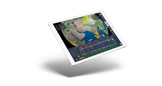
Figure 1
On the ground, the latest flight plan and weather are automatically refreshed and rendered in the application. The bulk of the upload takes place on the ground to control data costs. It includes a full view of the flight (including long haul or short haul, etc.). The solution is seamless and the pilot has very little data entry. They’ll need to look at a list for their flight and this will give them a strategic advantage on key dynamic situations that might occur during the flight, such as turbulence, icing, lightning or thunderstorm cells. Additionally, the solution uses multiple weather vendors’ data (DTN, WSI, Jeppesen, Météo-France and NOAA) who are best-in-class weather providers. Multiple providers give the pilot confidence that any event to which they are alerted will actually happen. For example, if one says, “this event might happen” and another doesn’t, the pilot will be in doubt. However, if two or three say “this event is going to happen” the pilot will have more confidence.
WHERE eWAS CAN HELP
The app has a strong and proven return on investment (ROI) story.
Better preparing the pilot
A study from NASA shows that clear air turbulence is one of the main reasons for injuries in civil air transport. The study evaluated the cost for those turbulence events at around US$100 million. Severe weather hazards can lead to big operational disruptions (diversions, delays, cancellations, aircraft groundings because of damage). eWAS makes the pilot aware earlier and provides a visualization of those weather phenomena, helps them to be strategically aware of any event long before the onboard weather radar would inform them and with much more clarity than the significant weather charts currently used. It’s there to complement the onboard weather radar so that, when they need to undertake a tactical re-route using the weather radar, they are ready for it.
Better protecting the cabin crew
Cabin crew are very vulnerable to turbulence events (a 2017 FAA study showed). The study concluded that an average of 15 cabin crew members flying for US carriers are severely injured each year. Similarly, SITAONAIR undertook a study of a major European airlines with more than 200 aircraft. The survey showed that there were 29 cabin crew injuries in 2015 which led to sick leave averaging 40 days and with cover required for those missed shifts. Taking all of those factors into account generated approximately €1 million in costs per year.
eWAS would reduce the occurrence of these events. It has allowed the airline in question to negotiate with their insurance company on the basis that eWAS delivers earlier awareness of potential significant weather, so flights are not as likely to experience those events, reducing the risk to cabin crew. The result is a documented saving of around €100,000 a year from their insurance premium.
A practical example from Air France
The example in figure 2 uses a flight from Johannesburg to Paris. The convective areas are colored orange and it can be seen that the flight will pass through some of them. Those convective areas are hard to spot on significant weather charts but with eWAS the pilots can use this information to co-ordinate service with the cabin crew during the ground briefing. For example, if service is scheduled for when the flight will be passing through that convective area, it would be a good idea to delay service until after the aircraft has passed through any turbulence. This makes it safer for cabin attendants and a more enjoyable dining experience for the passengers.
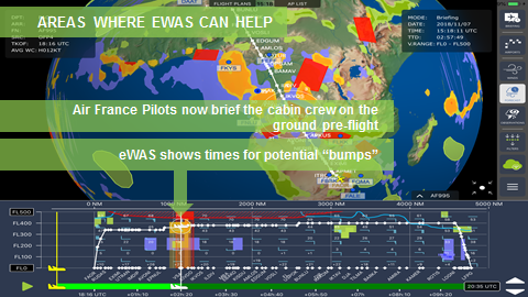
Figure 2
To explain the pilot experience, we have recorded a video with Olivier Béghin, Captain in the Boeing 787 fleet at Air France, explaining how he uses the eWAS information during briefing.
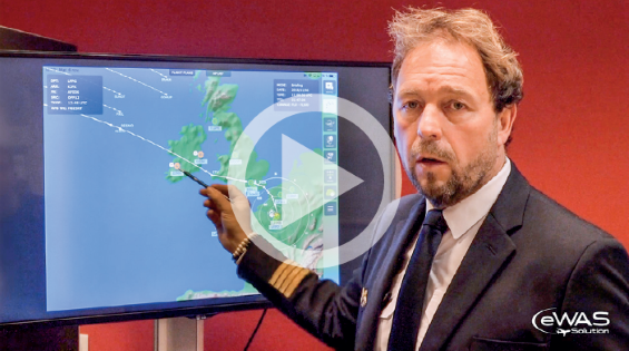
Figure 3 shows the Airport Analysis for a flight to Buenos Aires with some 50 airports provided to the pilots in the briefing package on the left.
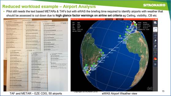
Figure 3
However, that might be of limited use because many of the airports will not be familiar to European pilots who don’t regularly fly to South America. They won’t know where the airports are or when they will be flying over them, so it takes a while to complete all of the analyses contained in that list and the flight log.
To check using eWAS (right of the figure), the pilot can rotate their view to see, at a glance, all of the airports. If they are marked green, that means the pilot can be confident the weather will be good at that airport with enough visibility and ceiling to carry out a visual approach. If an airport is marked with red, it will need low-visibility procedures, and if the airport is marked orange, it will be in between (ILS is probably needed). This really eases flight preparation for the pilot because they know which areas of the map to focus on and that makes flight-planning more efficient.
EXAMPLE: AVOIDING THUNDERSTORMS
Another example of enroute (figure 4.1) is an A320 afternoon flight from Orly to Montpellier.
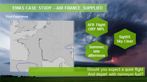
Figure 4.1
This is the significant weather (SigWX) chart that was delivered to the pilot with their briefing package. As you’ll see, the chart doesn’t show anything significant. There is some convection but it’s on the other side of the Pyrenees and shouldn’t have any effect on this flight. However, because it was summer and late afternoon the pilot was concerned about thunderstorms. They looked at eWAS (figure 4.2) to determine whether they should be departing with minimum fuel, as advised by the dispatcher, or whether they should consider some discretionary fuel to cope with CB (cumulonimbus cloud thunderstorm) avoidance.
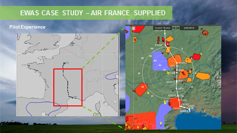
Figure 4.2
In eWAS, the pilot overlaid a satellite picture that had been analyzed by Météo-France and which showed active convection. The example shows the significant weather chart is inaccurate. Had the pilot relied on the significant weather chart and departed with minimum fuel and would have encountered issues with a number of CBs (cumulonimbus clouds that often contain thunderstorms) all along the route.
In figure 4.3, the blue broken line indicates the actual route the pilot flew when briefed with the full picture from eWAS.
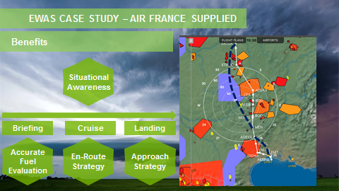
Figure 4.3
This example was taken from the ground. There is no in-flight connectivity on the A320, so the data was stored in an iPad before it was checked in-flight by the pilots as they planned their strategy. The benefits gained from eWAS are:
- Situational awareness: check the SigWX charts, see nothing; check eWAS, there is a very accurate prediction of weather hazards. In this case, it was convection but it is also the case with clear air turbulence models.
- eWAS can be used on the ground during briefing for an accurate fuel evaluation. In this example, more fuel would be taken because it’s appropriate in the circumstances and it’s better to have extra fuel and a good strategy than to have to make a fantastically costly diversion.
- In-flight, the blue broken line shows the trajectory flown. Soon after take-off, before encountering any CBs, the pilot was negotiating a new trajectory with the ATC to avoid the thunderstorms. The pilot reported that it would have been more intuitive to have avoided the CBs on the left because that was Montpelier, the destination, but that would have taken the aircraft into more weather issues. All the issues faced with the weather radar are also shown once you have reached a point. The weather radar will be blocked by the first convection cell so the pilot wouldn’t know what is happening behind that leading cell and therefore wouldn’t know the most efficient way to avoid the cells. The pilot used eWAS to negotiate a new enroute strategy to give clean air all the way, avoiding CBs or any other hazard.
- Before landing the situation was much the same; the pilot was on the route at around Mende but the STAR (standard terminal arrival route) was plotted directly through an active CB. The pilot was able to anticipate the CBs and negotiate with the ATC a new approach from the north; an approach that was in the approach manual and in the FMS and the cell was avoided.
Using eWAS turned what could have been a difficult flight with CBs all the way into a smooth journey because eWAS enabled a good strategy (enroute and at the approach) and an accurate fuel plan just in case the cells were moving or a hazard occurred just in front of the aircraft.
EXAMPLE: AVOIDING HIWC
We’ve now seen the savings that can be achieved by avoiding schedule disruption and injuries to cabin crew, some really strong ROIs (returns on investment). Now we’re going to focus on one specific case that can affect certain engine types where there is High Ice Water Content (HIWC), a phenomenon that appears high in the atmosphere around convective thunderstorm cells. Boeing has a good data source that it can provide to aircraft to avoid these types of areas. The HIWC can be ingested into the engine as small crystals that accumulate around the compressor and melt (the compressor is hot) in a cycle until eventually there are irregularities with power to the engine. Bits of ice can drop off and cause rotor tip damage and it’s possible to reach a situation where the aircraft is forced into a diversion – which was the real event illustrated in figure 5.
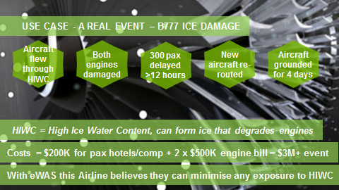
Figure 5
A Boeing 777 encountered an icing event that became so severe it had to divert. But the costs soon mount up. It cost $200k to accommodate the passengers in a hotel; there was a $500k bill to replace each engine; the cost of the aircraft not operating its planned sectors; and the cost of another aircraft that had to come out to take the passengers to their intended destination. It can quite quickly add up to a $3 million event. If you take the advice from Boeing to the cockpit and can show your insurers that you tried to avoid these ice crystal areas but still have that damage, the insurance company can pick up some 50 per cent of the engine repair cost. This is a good example of eWAS enabling cost avoidance through the use of high ROI-generating data in a real world situation.
Many of the eWAS customer base initially start using eWAS in a non-connected mode in-flight since it still has a rich source of forecast weather that lasts for many hours, outlasting even the longest long haul sector. However, some weather phenomena are very fast changing and it makes sense to connect the eWAS app in-flight. To this end SITAONAIR has developed a module called AppsConnect to make in-flight updates possible, as per figure 6.
AppsConnect uses least-cost routing logic to employ the most cost effective link (3G/4G, SATCOM, SB-S, Cabin Link if approved) to provide in-flight updates to approved apps such as eWAS Pilot.
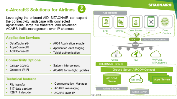
Figure 6
SUMMARY
eWAS is now used by circa-20,000 pilots including pilots from Etihad Airways, Singapore Airlines, Air France and many more.
Improved weather awareness will deliver broad benefits. It makes the pilot’s job easier and protects cabin crew from injury and passengers from discomfort or injury. Plus, very importantly, it can deliver huge financial savings and brand value to the airline via more reliable and fewer disrupted flights.
Contributor’s Details
 Matthieu Durand-Gobert
Matthieu Durand-Gobert is a Flight Operations Engineer for Air France, responsible for the Flight Operations Support team, in charge of Air France EFB and mobility projects for pilots. He played a big role in the creation of the eWAS Pilot application, aiming to provide a real time depiction of all-weather hazards to pilots. Matthieu has an extensive experience in Flight Operations and Dispatch operational processes, including Flight Planning and Flight Watch.
 Toby Tucker
Toby Tucker is a Portfolio Director for SITAONAIR, responsible for product strategy on EFB, CrewTab and, more recently, eWAS Pilot application. He has experience in general management and business development, plus knowledge of airline operational processes and systems. Accomplishments at SITA and SITAONAIR include development of a web-based Flight Planning solution, introduction of an FMS Wind service promoting better fuel efficiencies to aircraft in-flight plus set up and deployment of SITA’s EFB solution.
Air France

Air France is a leading global player in passenger transport, cargo transport and aircraft maintenance. From its hubs at Paris-Orly and Paris-Charles de Gaulle airports, the airline operates flights to 195 destinations and 91 countries. Air France has also set up a joint venture with Delta dedicated to the joint operation of several hundred transatlantic flights every day.
SITAONAIR

SITAONAIR is the air travel industry’s trusted connected aircraft service expert, helping airlines around the world realize the full potential of nose-to-tail connectivity. Whether personalizing the passenger experience, streamlining cabin and cockpit operations, or optimizing maintenance procedures, SITAONAIR solutions enable airlines to navigate the complexity of connectivity and unlock connected aircraft value.

GTD is a high-tech company, committed to the design, integration and operation of complex, mission-critical applications and systems throughout the world.
We have an experienced team which carries out projects of great technical difficulty and state-of-the-art systems in space, aerospace, aviation and energy industries, as well as scientific facilities, critical infrastructures and maritime and port facilities, making GTD the ideal choice for your projects.
Comments (0)
There are currently no comments about this article.
To post a comment, please login or subscribe.